


Quintana Roo Mexico Map
You can click on extend screen on the “Quintana Roo Mexico Map” to use the map in fullscreen and be able to filter the sites by map categories such as ATMs, gas stations, energy stations for electric vehicles, archaeological sites, Hospitals, Cenotes Quintana Roo, Quintana Roo Mexican Restaurants, Quintana Roo Excursions, “things to do in Quintana Roo” and things to do throughout the Yucatan Peninsula, Quintana Roo Restaurants, Quintana Roo mexican grill, Quintana Roo Beaches and more.
Quintana Roo
Quintana Roo is one of the 31 states together with Mexico City that make up Mexico. Its capital is the city of Chetumal and its most populous city is Cancun. Quintana Roo is located in the Yucatan Peninsula Southeast Region of Mexico limiting the North with Yucatan and the Gulf of Mexico to the East with the Caribbean Sea, to the south with Belize and to the west with Campeche. You can see in Quintana Roo Mexico Map.
According to a census held in 2020 Quintana Roo has a population of 1,857,985 inhabitants and is together with Baja California Sur the youngest state in the country, its most populated cities are Cancun, Playa del Carmen, Chetumal, Cozumel, Tulum and Felipe Carrillo Puerto.
Quintana Roo begins as a state in 1902 when the federal territory of Quintana Roo is created and was formerly populated by the old Mayan civilization. At present, some ethnic groups survive and there are multiple archaeological sites that show the demographic concentration that the area had in the past, among which are Chacchobén, Chakanbakán, Chamax, Cobá, Dzibanché, Ichpaatán, Kohunlich, very much, OxTankah, Tankah , Tulum, Tupak, Xel-Há and Xcaret. You can see in Quintana Roo Mexico Map.
The state of Quintana Roo arises when President Porfirio Díaz sought economic and political control of the southern border of Mexico with Belize because the United Kingdom was there so it was decided to put strengths in the south of the state of Quintana Roo nearby nearby of the border with Belize as in Bacalar. You can see in Quintana Roo Mexico Map.
Holbox Island
Holbox in Mayan means “black hole”, Holbox is a Mexican island located north of the Yucatan Peninsula, it is located inside the state of Quintana Roo and has an extension of 40 km long and 2 km wide with about 34 km of beach towards the North. The population of Holbox is approximately 1,200 inhabitants according to the 2005 census.
Holbox is a destination of adventure and also rest tourism. One of the main activities of the inhabitants of Holbox Island is lobster fishing governed by a ban. Holbox white sand walks along with its crystalline sea are comforting.
Hotels in Holbox
There are different Hotels in Holbox and sites to make camping, A lot of hotels in Holbox have Bungalows. There are famous villas and hotels in Holbox like villas flamingo holbox and mystique holbox. You can see it in the Quintana Roo Mexico Map.
Holbox Island attractions:
Yalahu in Holbox Island
It is located 30 minutes from Holbox Island, it is a spring of crystalline waters that contains as much beauty as history is said that this spring has healing properties so this beautiful water eye is considered as the source of youth, formerly it was a port Merchant important for the state of Quintana Roo. You can see it in the Quintana Roo Mexico Map.
Isla Pájaros (Birds Island) in holbox island
Isla Pajaros is a small islet covered with mangrove and cactus located in the Yalahu lagoon, on this island they inhabit a great diversity of birds so there are 2 viewpoints and walkers in order to minimize direct contact with birds , the birds that can be observed from the Isla Pájaros are the flamenco, cormorant, frigates, pelicans, wild gaviotas coma among many more. You can see it in the Quintana Roo Mexico Map.
Isla Pasión in Holbox Island
Isla Pasion is a small islet that is 10 minutes from Holbox by boat as on this island you can enjoy virgin beaches with a quiet atmosphere and far from civilization. You can see it in the Quintana Roo Mexico Map.
Cabo Catoche in Holbox Island
In Cabo Catoche is a tip on the coast of the Gulf of Mexico that is approximately 53 km north of Cancun, during the colonial era a Catholic temple was built which is known as Boca Church Punto there are no passable paths to arrive through Cabo Catoche, can only be reached by sea and you can also visit the ruins of Boca Church. You can see it in the Quintana Roo Mexico Map.
Holbox Island History
Holbox Island has been inhabited since time immemorial by the Mayan Civilization.
In the nineteenth century the Holbox Island received many survivors fleeing from the Mayan social rebellion known as the caste war and in 1891 the inhabitants of Holbox formed the party of the islands based in Isla Mujeres.
The federal territory of Quintana Roo was created, so Holbox Island was integrated as a sub -prefecture of the Northern District, in 1910 the population of the state was grouped into 8 municipalities that were divided into 3 areas that still persist: north, center and south; The northern zone included the municipalities of Holbox, Cozumel and Isla Mujeres, at that time Holbox Island was the municipal head of 8 locations but shortly after in 1921 Isla Mujeres absorbed them.
It is a natural refuge of several species both in danger of extinction and threatened and most inhabitants are interested in protecting this area. Reason why Holbox Island host sustainable tourism projects looking for a minimum impact on the various ecosystems such as endemic fauna and vegetation in the area; Within the island there is no pavement and there are few cars, all the streets are of white sand which allows pedestrian displacement, traditional transport media are electric, gasoline and bicycle carts.
Isla Mujeres (Women Island)
Isla Mujeres (Women Island)” is an island located in the Caribbean Sea very close to the Yucatan Peninsula to the southeastern Mexico, Isla Mujeres is in the state of Quintana Roo Mexico and its warm and transparent waters are the perfect place for the Delfines, turtles and “Whale Shark Isla Mujeres”; Swimming with these aquatic species are some of the most attractive activities that can be carried out in Isla Mujeres. If you want to know more about swimming with “Whale Sharks” click here.
To get to Isla Mujeres you can take Ferry Isla Mujeres, boats from Puerto Juárez, Punta Sam and the Hotel Zone of Cancun. “You can see Ferry Isla Mujeres in Quintana Roo Mexico Map “
Interesting sites in Isla Mujeres (Women Island):
Hacienda Mundaca Isla Mujeres
One of the attractions of Isla Mujeres is the Mundaca farm which was a livestock agricultural farm popularly known as the Hacienda del Pirata Mundaca, which is related during the caste war with the traffic of Mayan prisoners to Cuba. You can see this place in Quintana Roo Mexico Map.
Punta Sur Isla Mujeres (Women Island)
Another attraction of Isla Mujeres is Punta Sur that is the place where archaeological vestiges of the temple are found to Ixchel, the Mayan goddess of love and fertility. Punta Sur is the highest part of the island reaching about 20mts above sea level and is a natural formation adjacent to the “Garrafon” reef that provides a view of the Caribbean Sea, Cancun and the Bay of Isla Mujeres itself. You can see Punta Sur in” Quintana Roo Mexico Map.
Playa Norte Isla Mujeres (Women Island)
Playa Norte Isla Mujeres is the main tourist area of Isla Mujeres, in this area is the overseas ferry dock, beaches, hotels, several restaurants, Beachclubs and Golf Cart Rentals Isla Mujeres
Cross in Machote Reef Isla Mujeres (Women Island)
Another attraction of Isla Mujeres is the Cross of the Bay that is a place where a bronze cross was placed in the Machot Arrecife on August 17, 1857, the cross of the Bay measures 3 m high and weighs about 1 ton and It is 12 m deep in the sea, said monument pays tribute and recognition of the men and women who died at sea.
Turtle farm in Isla Mujeres (Women Island)
Tortu-Granja is a natural zone for turtles in which turtles come to spawn between the months of May and September. The eggs are placed in safe areas to keep them safe from predators and after birth the turtles are placed in ponds and are accompanied to the sea by the children of the local schools and the tourists who help them return to their marine habitat.
Snorkel Isla Mujeres (Women Island)
The Snorkel Isla Mujeres can be practiced in several places of Isla Mujeres due to its privileged location.
Rafa’s park is a natural park in Isla Mujeres that owes its name to an invaluable reef that due to its minimum depth and soft current allows us to approach the underwater life of the Caribbean Sea, located on the southern tip of the island and has A majestic coral reef in which diving and snorkeling is practiced.
The spots reef is very close to the southern tip of the island and has a coral bank 12 km long by 700 m wide where diving and snorkeling can be practiced can be there by boat.
The Cave of School Sharks is located east of the island This place is surrounded by coral formations and diving and snorkeling is practiced
The Underwater Museum of Art has more than 440 sculptures which are submerged in the spots exhibition area near the Isla Mujeres, it also has 17 sculptures in the Nizuc area south of Cancun. “You can see this in Quintana Roo Mexico Map.
Whale Shark Isla Mujeres (Women Island)
Whale Shark Isla Mujeres is one of the most amazing kind of nature, The Whale Shark, an Aquatic Species that has existed on our planet for approximately 60 million years; Whale Sharks, a calm and social species that likes to interact with humans. If you want to know more about swimming with Whale Sharks click here.
Blue Flag Beaches
Beaches Blue Flag, the beaches of Isla Mujeres have received the Blue Flag certification granted by the European Foundation of Environmental Education to the beaches that have reached excellence in environmental management and management and security and services The application of environmental education activities and water quality this certification is valued every year.
Isla Mujeres Golf Cart Rental
Other very popular activity in Isla Mujeres is Isla Mujeres Golf Cart Rental to tour the entire island, there are many companies that allow Golf Cart Rentals Isla Mujeres per hour and per day. You can see Golf Cart Rentals Isla Mujeres in Quintana Roo Mexico Map.
Ferry Isla Mujeres (Women Island)
To get to Isla Mujeres you can take Ferry Isla Mujeres, boats from Puerto Juárez, Punta Sam and the Hotel Zone of Cancun. You can see Ferry Isla Mujeres in Quintana Roo Mexico Map.
Isla Mujeres History
Isla Mujeres was inhabited by the Mayan civilization and the island was consecrated to the goddess Ixchel what is the Mayan goddess of the moon, love and fertility; The Maya performed female sculptures on the beaches of Isla Mujeres to pay tribute.
Upon arriving the Spanish conquerors and observing the sculptures they baptized her as “Isla Mujeres.”
On the south of the island there are vestiges of a Mayan temple, archaeologists know that Isla Mujeres was a sanctuary dedicated to Ixchel and Mayan women had to make a pilgrimage to the island as part of their passage from girl to woman. You can see Sanctuary to Ixchel in Quintana Roo Mexico Map.
Isla Mujeres was also a shelter and home with famous pirates and slave traffickers such as Fermín Mundaca and Marecheaga
The island was discovered by the expedition of Francisco Hernández de Córdoba in 1517
During the caste war in Yucatan, Mayan and Yucatecan fishermen set a town called “Dolores” in Isla Mujeres.
In 1867 Dolores was already considered a town, for January 28, 1891 Isla Mujeres was considered a municipal head of the Yucatan Islands Party. Isla Mujeres began to take great importance for tourism thus marking its new beginning. On January 12, 1975 Isla Mujeres is established as one of the 7 municipalities that were born along with the official free and sovereign state of Quintana Roo. You can see quintana roo in Quintana Roo Mexico Map.
Isla Mujeres Real Estate
The Isla Mujeres Real Estate has grown a lot in the last years, many properties in Isla Mujeres can be found for sale.
Cancun
Cancun means “nest of snakes” in Mayan, Cancun is located in eastern Mexico approximately 1,600 km from Mexico City, Cancun is located in the Mexican state of Quintana Roo.
Cancun is the largest city in Quintana Roo with 888,797 inhabitants according to the 2020 population census. Cancun is considered a world-class tourist destination by the World Tourism Organization.
Cancún began operations in 1974 as a tourist center planned by FONATUR.
Cancun has undergone a remarkable transformation since 1974, Cancun was previously considered a fishing village.
Cancun is the main tourist destination in Mexico along with Mexico City and the Riviera Maya, in addition, the Cancun international airport is the second with the most movement of passengers, which makes Cancun the main tourist destination in Mexico.
Cancun will also be within the Railway Network under construction called “the Mayan Train” you can see it on the Quintana Roo Mexico Map highlighted in yellow.
The Mayan Train is a megaproject that has been underway since December 2018 in southeastern Mexico. It is planned as a regional train for locals, tourists and cargo, is planned to begin operations in early 2024.
The Mayan Train line starts in palenque chiapas and travels northeast towards Cancún in Quintana Roo through 2 routes that circle the yucatan peninsula the project aims to connect tourist destinations in the caribbean with lesser known sites inland, including mayan sites history from which it derives its name. you can see it on the Quintana Roo Mexico Map highlighted in yellow.
Cancun is divided into 5 zones, the first and the most important touristically is Cancun Island, which is where the hotel zone of Cancun is located, in addition to being the area where most of the beaches and tourist activities are concentrated; the second area of Cancun is the urban area which is where the bulk of the population lives; The third zone is Puerto Juárez, which is the place where the 2 main docks are located to embark and cross to Isla Mujeres, located just 7 km from the port; The fourth area of Cancun is called the Ejidal Strip, which is an area of irregularly distributed settlements in the northern part of the city in the municipal limits of Isla Mujeres and Alfredo Bonfil.
Cancun is located northeast of the Yucatan peninsula and from Cancun you can clearly see Isla Mujeres to the north of the city in the so-called women’s fence, which is the area through which various boats and boats-cross that transport the inhabitants all day from the island to the mainland.
The hotel zone is the most important tourist area in Cancun since it is where most of the beaches and tourist activities for which the destination is recognized are concentrated, Cancun Island is a strip of land in the shape of a number 7 with a length of 23 km. you can see map of cancun hotel zone on the Quintana Roo Mexico Map.
Isla Cancún houses most of the hotels and beaches, as well as residential areas such as Isla Dorada, the Poktapok golf course and the entrance to the exclusive area of Puerto Cancún, which is the most ambitious and important residential area in the city, Isla Cancún is united to the mainland by 3 bridges: the calinda bridge, the club med bridge, and the nizuc bridge, you can see it on the Quintana Roo Mexico Map.
In the urban area of Cancun is where the bulk of the population of Cancun lives and is divided into neighborhoods, subdivisions, superblocks or regions such as the regular ones perfectly delimited by paved streets and avenues that have basic services of electricity, drinking water, telephone service, sanitation and internet. In the urban area of Cancun is where most of the city’s political, educational, cultural and service institutions are located.
The Cancun City increases in size every year due to the growth it has experienced since its inception which has continued to this day, so that the zone of the Ejidal strip of Cancun each year has new housing and infrastructure projects such as subdivisions , residential, and new neighborhoods where visitors from all over Mexico and other parts of the world arrive every year to look for their new home in Cancun.
Another area of Cancun is Alfredo Bonfil, which is one of the 3 delegations of the municipality of Benito Juárez, the population of Alfredo Bonfil originally started with settlers from the north of Mexico with the mission of contributing to the demographic increase of Quintana Roo to reach the category of free and sovereign state in 1974 and is located 8 km from downtown Cancun on the federal highway that goes to the international airport and the Riviera Maya, you can see it on the Quintana Roo Mexico Map.
Weather in Cancun
The climate in Cancun is characterized by the influence of hot ocean currents because Cancun is located on the eastern coast of the continent, which favors a warm and rainy climate.
The predominant climate in Cancun is warm sub-humid with frequent rains during the year, although more abundant in summer. The average temperature in Cancun is between 25° Celsius and the hurricane season begins in mid-June.
December weather in cancun:
The December weather in Cancun is pleasant with an average temperature of 26.8 degrees Celsius and little rain.
Flora in Cancun
The vegetation in Cancun is characterized by being medium forest, lowland forest, lowland flooded forest, mangrove savannah, flooded palm grove and coastal dune vegetation.
In the center between the island of Cancun and the urban area of Cancun we find the enormous Nichupte Lagoon in which we can find species of flora characteristic of the region such as the acacia, the annona, baleno, cameraria latifolia, the palm, the coconut, the dyewood, sapodilla, chechén, pouteria chiricana, palm, red mangrove, and chit palm, you can see the Nichupte Lagoon on the Quintana Roo Mexico Map.
Wildlife in Cancun
Given the diversity of flora that exists in Cancun and its surroundings, this ecosystem makes it possible for there to be a great diversity of fauna in Cancun and its surroundings, such as many varieties of crustaceans, oysters, various species of fish such as cyclic fish and cyclic poe fish, the American eel; We can also find bird species in Cancun such as the blue-winged egret, the carao, the squacco hawk, the hocofaisán, the heron, the palomero falcon, the long-legged hawk, the Yucatecan bolsero, the curculado bolsero, the king vulture, the swallow marina, the ocellated turkey, the Yucatecan parrot and the Mexican Zanate.
Turtles such as the loggerhead, the white turtle, the leatherback turtle, and the sea turtle reproduce in the Cancun area, as well as the boa constrictors, like the grated hollow, like the garrobo, the green iguana, the howler monkey, the spider monkey, the manatee and the crocodile.
Cancun History
During pre-Hispanic times, the Mayans maintained a commercial network from the Terminos lagoon to Honduras, for which they established maritime routes that ran along the entire coast of the current state of Quintana Roo. For this reason, the Mayans built buildings along the Caribbean Sea along Cancun and the Riviera Maya to carry out commercial exchanges, monitor and help navigation.
According to archaeological studies carried out in the archaeological site of El Meco and the archaeological site of El Rey, which were inhabited points until the 16th century, in the chronicles of the Indies a locality with the name of Velma is described, it is probable that this locality corresponds to the archaeological site of “El Meco” you can see it on the Quintana Roo Mexico Map.
The first Spanish Navigator to explore Cancún and Isla Mujeres was Francisco Hernández de Córdoba in 1517.
The first known map of Cancun was made by cartographer Juan de Dios González in 1776. During the 19th century, Cancun was visited by other Navigators such as Joan Loyd Stephens, Frederick Catherwood and Captain Richard Owen Smith.
Starting in 1967, INFRATUR decided to carry out a master plan in Cancun with the aim of building a world-class tourist destination as an engine to contribute to the Mexican economy.
Cancun has been the venue for various international forums due to its privileged location. In 1981 Cancun was the venue for the International Meeting on Cooperation and Development; in 1983 Cancun hosted a meeting of the accounting group that achieved the peace plan in Central America and the Caribbean; in 1989 Cancún was the seat of the miss universe beating Tel Aviv and Viña del Mar that also competed for the seat; In 2003, the Fifth Ministerial Conference of the World Trade Organization was held in Cancun.
Cancun has very safe infrastructures against hurricanes as a result of the impact of hurricanes Gilberto and Wilma, as proof of this, all the hurricanes that have impacted Cancun after Willma have not caused serious damage.
Cancun International Airport
Cancun International Airport is the one that receives the most international traffic in all of Mexico.
Cancun International Airport is the second largest air terminal in Mexico after the international airport of Mexico City, today the Cancun international airport has 2 runways and a considerable number of flights operate, it has a new control tower that is the tallest in Latin America and it is number 18 worldwide, Terminal 3 in Cancun is recently built and was created with energy savings in mind, you can see Cancun Airport on the Quintana Roo Mexico Map.
Cancun Transport Services
Cancun has a huge variety of urban transport which greatly speeds up mobility in the urban area and in the hotel zone such as autocar, turicun and maya caribe; It also has land transportation to other cities in the Yucatan Peninsula through the ADO bus stations among other stations.
Cancun is also home to various television, radio, internet and print media outlets such as sipse TV, Cancun, channel 10, turquoise radio, the Quintana Roo system of social communication, pirate fm, radio formula QR, caribbean fm, among many other media.
Demographics in Cancun
Cancun is a cosmopolitan city due to its recent creation and development, which has caused that until today there is a mix of inhabitants from different cultures and regions of Mexico and other countries of the world due to the numerous job offers that it presents in tourist spaces.
In Cancun, the folklore, gastronomy and customs that prevail come from the neighboring state of Yucatan and the Mayan culture due to the location of Cancun.
Cancun is a multicultural city due to the mixture of cultures from different countries that inhabit the city, as it has a strong influence from countries such as Cuba, Puerto Rico, South Korea, countries in Europe, Africa, the United States, Canada, China, Russia, Japan and several Latin American countries such as Argentina, Colombia and Venezuela.
Religions in Cancun
Cancun is the city where the main religions of the municipality are concentrated, where the Catholic religion covers approximately 50% of the population. We can also find the presence of other religions such as Protestants, Presbyterians, Baptists, Methodists, Pentecostals, Neo-Pentecostals, Adventists, Mormons, Jehovah’s Witnesses, Jews and other religions.
Riviera Maya
The Riviera Maya is a tourist area of Mexico located on the Caribbean Sea coast in the state of Quintana Roo and extends along the coast of beaches of the coast, it is located in the eastern part of the Yucatan Peninsula.
The Riviera Maya is considered to begin southern Cancun in the town of Puerto Morelos and extends to the south covering important cities of Quintana Roo such as Puerto Morelos, Playa del Carmen, Puerto Aventuras, Akumal, Tulum and Coba until reaching the reserve Ecological of Sian Ka An. You can see in the “Quintana Roo Mexico Map”.
The Riviera Maya has approximately 405 hotels and resorts of international class, 5 stars and other categories that offer at least 43,500 rooms, most hotels and resorts have all inclusive system.
Weather in Riviera Maya
Temperatures in the area of the Riviera Maya ranges between 24 and 29 ° C throughout the year and is characterized by having a humid climate with rains in summer.
In the Riviera Maya you can find very diverse flora and fauna with land animals such as jaguars, deer, wild boars, spider monkey, foxes, mapaches, among many others
Riviera Maya Mexican Restaurants
There are many Mexican Restaurants in Riviera Maya, you can see the Riviera Maya Mexican Restaurants in the “Quintana Roo Mexico Map”
Cenotes Riviera Maya
There are many cenotes in Riviera Maya, you can see the cenotes in the “Quintana Roo Mexico Map”
Riviera Maya Excursions
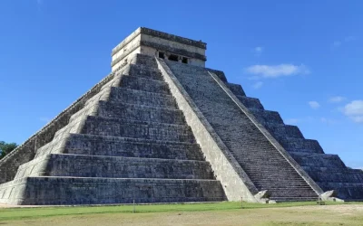
There are multiple Riviera Maya Excursions and excursions for all Yucatan Peninsula to archaelogical sites like Chichen Itza, Coba, Tulum, Ek Balam and others. You can get more information about excursions here.
Riviera Maya History
The Riviera Maya was originally inhabited by the Mayan people since 200 AC, the Mayan cities located in the Riviera Maya are characterized by having had constructions in which mathematical bases and high level of precision, arts and engineering were used, being good representatives of culture. You can find various museums dedicated to the past of the Riviera Maya such as the Xcaret archaeological site and also the archaeological areas of Tulum and Coba, it is known that Cozumel was a pilgrimage place between the natives and the influence of the Mayan culture can Notice in the archaeological zones of Cozumel such as San Gervasio and Santa Rita. You can see in the “Quintana Roo Mexico Map”
The tourist boom in the Riviera Maya began in 1993 with the arrival of new investments to the area of Playa del Carmen such as the Hotel Beach Complex of Car, as well as hotels such as the Robinson Tulum that began to give a boost in the tourist activity In the Riviera Maya. The continuous growth to this day and currently in that area there are more than 405 international class hotels and resorts.
Playa del Carmen
Playa del Carmen is a Mexican city located in the state of Quintana Roo with an approximate population of 304,100 inhabitants according to the last census of the year 2020.
Playa del Carmen is located within the tourist area called Riviera Maya with a coast on the Caribbean Sea, the main economic activity in Playa del Carmen is tourism.
Playa del Carmen has had a great growth as a city since only 10,000 inhabitants lived in Playa del Carmen in 1996; In 2003 there were already 40,000 inhabitants, compared to the current ammount of approximately 300,000 inhabitants, it is a rapid growth compared to other cities from Mexico. In the same way, the Real Estate Playa del Carmen and houses in mexico for sale for inhabitants of other countries have increased considerably, especially due to the boom in investments in physical goods and fixed assets as a consequence of the increase in inflation in the “OECD” countries since 2019 and the Pandemic since 2020.
Playa del Carmen Meaning:
In pre-Hispanic times Playa del Carmen was called “Xaman há” which means “water from the north” in the Mayan language and was a starting point for the Mayan pilgrimage to the sanctuary of the Goddess Ixchel in Cozumel.
Economy Playa del Carmen
Playa del Carmen is one of the most visited places in the Riviera Maya so that tourism is the most important economic activity, making the rest of the economy depend directly or indirectly on this activity, also Playa del Carmen has a connection to other attractions related to ecotourism due to its location such as Xcaret, Xplor, Cozumel, Tulum, Xelha, Sian Ka an and Cancun You can see all these sites it in the Quintana Roo Mexico Map.
The highway Cancun to Playa del Carmen & Playa del Carmen From Airport are the ones with the highest flow of vehicles in the state of Quintana Roo; The vehicles flow has also increased considerably on the Playa del Carmen to Tulum route. You can see interesting sites & Cenotes on these routes in the “Quintana Roo Mexico Map”.
The most famous street in Playa del Carmen is the fifth avenue of Playa del Carmen which is the street most visited by national and foreign tourists, this avenue is around 4 km long and is a very safe and crowded pedestrian avenue especially by the afternoons and evenings. Most of the commerce is concentrated here, from craft and souvenir shops to restaurants, bars and nightclubs such as Coco Bongo Playa del Carmen. You can see interesting sites in the “Quintana Roo Mexico Map”.
Other iconic places in Playa del Carmen is the “beach Playa del Carmen” where we can find Beach Clubs in Playa del Carmen such as Playa Mamita’s Beach Club; Other iconic places in Playa del Carmen are the founders park, the Xaman-ha aviary, the Nuestra Señora del Carmen parish and Coco Bongo Playa del Carmen. You can see interesting sites in the “Quintana Roo Mexico Map”.
The cultural diversity of Playa del Carmen can be seen in the House of Culture, as well as in La Ceiba Park, which are places where pictorial, cultural and craft exhibitions are presented, workshops on literature, painting, music, dance, etc. theater and much more for the entire population.
The most famous celebrations in Playa del Carmen are the Playa del Carmen Carnival, the Virgen del Carmen festival, La Guelaguetza, the Sacred Mayan Journey and the Riviera Maya Jazz Festival.
Playa del Carmen has all the necessary basic services such as urban transport provided by autobus and vans, taxi services and motorcycle taxi service, in addition to foreign transport in its ADO bus stations that allow transportation to Cancun, Tulum and many other parts of the Yucatan Peninsula, Playa del Carmen also has maritime transport to transport passengers to the island of Cozumel. You can see interesting sites in Cancun, Tulum, Cozumel and Yucatan Peninsula in the “Quintana Roo Mexico Map”.
Playa del Carmen also has the “Playa del Carmen Airport” that allows the takeoff and landing of small aircraft. You can see “Playa del Carmen Airport” in the “Quintana Roo Mexico Map”.
Real Estate Playa del Carmen
The Real Estate Playa del Carmen and Houses in Mexico for sale for inhabitants of other countries have increased considerably, especially due to the boom in investments in physical goods and fixed assets as a consequence of the increase in inflation in OECD countries since 2019 and the Pandemic since 2020.
In Playa del Carmen and Cancun you can find many “Real Estate” companies with extensive portfolios of land, houses, apartments and luxury villas.
There are many hotel and apartment complexes in Playa del Carmen such as “Playacar” and “Mayakoba”. You can see Playacar and Mayakoba in the “Quintana Roo Mexico Map”.
Excursions in Playa del Carmen
Many Excursions in Playa del Carmen can be found for all the places of interest in the Riviera Maya, Quintana Roo and Yucatan, you can find more information about tours here.
Playa del Carmen History
In pre-Hispanic times Playa del Carmen was called “Xaman há” which means “water from the north” in the Mayan language and was a starting point for the Mayan pilgrimage to the sanctuary of the Goddess Ixchel in Cozumel. You can see Cozumel island in the “Quintana Roo Mexico Map”.
During the 16th century the Spanish invaded and conquered most of the Mayan sites, however unlike many others, Playa del Carmen never became a Spanish settlement as it was almost always inhabited by Mayans and was considered a fishing village.
The first modern settlement in Playa del Carmen dates back to the beginning of the 20th century when a community of fishermen, coconut producers and chewing gum trees settled there.
The foundation of Playa del Carmen was due to a chewing gum colonizing company from the eastern coast of Yucatan that in 1908 obtained from the government concesión from Porfirio Díaz to exploit forest resources.
In the 1980s, Playa del Carmen was considered a transit town with less than 1,500 inhabitants.
Playa del Carmen is characterized by being made of highly permeable limestone rock and has many “Playa del Carmen cenotes” which are expansions of complex underground pluvial networks that sometimes make their way to the sea.
The climate of Playa del Carmen is considered sub-humid with rains in Summer and the average temperature of Playa del Carmen is 25.8 degrees Celsius.
Given the great population growth that Playa del Carmen has had according to a census in 2014, 60% of the population of Playa del Carmen was considered non-native and 10% immigrant.
Cozumel
In Cozumel many activities can be carried out due to its privileged location. Cozumel is an island made of limestone, the same that comes from the reefs, which is why it also has several cenotes. Cozumel has a humid climate with abundant rains in summer and little in winter as it is surrounded by warm waters of the Caribbean Sea as well as the current of the Yucatan Channel, which causes the prevalence of high pressures, making it an island with high humidity. All these characteristics added together result in Cozumel being a spectacular and paradisiacal island since it has beautiful beaches (Quintana Roo Mexico Map) with clear sand and crystal clear water covered by spectacular reefs of various colors(see Quintana Roo Mexico Map) with an immense variety of flora and fauna since due to their characteristics, the reefs of the world concentrate 25% of the aquatic fauna and flora. Cozumel is also rich in terrestrial flora and fauna with 27 species of animals endemic to the island of Cozumel such as the pygmy raccoon, the island coati, the Cozumel lizard, the cozumel mockingbird and the Cozumel vireo. In the Quintana Roo Mexico Map you can find most of the activities.
Cozumel History
The latest research indicates that the first settlers of the Cozumel island arrived there around the 2nd century BC. It is believed that these individuals were part of semi-nomadic Caribbean groups dedicated to fishing and hunting; As of the 3rd century, the Mayans began to populate the island with a cultural level that was definitely higher than their predecessors, since they practiced agriculture and mastered architectural techniques, which is why in Cozumel there are traces of their activity in some ruins and remains of pottery found in the north center of the island such as “San Gervasio” and “Santa Rita”. Already by the year 1200 of our era during the Mayan Apogee, “the Cozumel island” was a trade center with distant lands , since merchandise arrived in Cozumel from distant places, many of the items were stored in canoes before being sent to other distribution points. You can find San Gervasio in Quintana Roo Mexico Map.
From the year 1500 of our era, the first Spanish explorers began to arrive, such as Juan de Grijalva who was the first to land on the island and Hernán Cortés who would later travel to the capital of the Aztecas “Tenochtitlan”. During the colonial era, agricultural activities prevailed on the Cozumel Island.
Cozumel has several traditional festivals such as the Cedral fair which takes place in the town of Cedral (see Quintana Roo Mexico Map) in Cozumel in which a miracle attributed to a cross during “the caste war” is celebrated.
Another traditional festival in Cozumel is “The Cozumel Carnaval” which is one of the oldest in Mexico and one of the most important; “The Cozumel Carnaval” is a mixture of diverse cultural expressions, dances and rhythms from the Yucatan Peninsula and the Caribbean. The Cozumel Carnival has its origins in 1874 and is a tradition started by migrant families from Yucatan, Campeche and other places who found their new home in Cozumel.
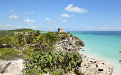
Tulum
The city of Tulum is a city in Mexico in the state of Quintana Roo and is located at the southern end of the Riviera Maya, Tulum is one of the main international tourist destinations, it was founded approximately in 1860 by María Uicab with the name of Tulum Because this city is next to the archaeological ruins of Tulum built by the Mayan civilization.
The distance of cancun to tulum is 130.7 km.
María Uicab who founded Tulum’s contemporary city was a priestess of the “Parlante Cruz” to which the inhabitants of the area called the “Patroness Holy” during the caste war fought in the Yucatan Peninsula between the Yucatecan government and the peoples Maya, the Yucatan Republic Army chased María Uicab and her destiny is unknown.
The small town of Tulum remained a long time as a place of passage between the south of the state of Quintana Roo and the north of the state of Quintana Roo and as tourism in the state of Quintana Roo increased considerably, Tulum developed as a tourist destination, in 2015 Tulum was appointed in Mexico “Pueblo Mágico(Magic Town)” and has had considerable population growth since it has natural attractions and Mayan vestiges, the Tulum Airport & Mayan train are under construction. You can see the “Tulum Airport” in the “Quintana Roo Mexico Map”
In Tulum they live approximately 304,942 inhabitants according to the last 2020 census.
Tulum can currently be considered a multicultural city due to the large number of foreigners who have decided to live in Tulum, it is a very quiet city and with many attractions nearby, it is very common to observe the inhabitants of Tulum to use bicycles in addition to finding many hotels Ecological since the Eco Friendly culture in Tulum is widespread.
Tulum’s climate is warm subhumid with rains in summer and the average annual temperature is 25 ° C.
Tulum Meaning:
Tulum means wall in Maya and its name is due to the wall that protects the archaeological site of Tulum, but in ancient times during the Mayan Apogee the archaeological site of Tulum was called “Zamá”, what means dawn in Mayan.
In Tulum and near Tulum there are several Interesting Sites:
Ruins Tulum
The Ruins Tulum were built by the Mayan Civilization and are the main attraction which receives many tourists from Cancun and Playa del Carmen; You can see the Ruins Tulum in the Quintana Roo Mexico Map.
Ruins Coba
Another site of interest near Tulum is the archaeological ruins of Coba that are about 40 km northwest of the city, these archaeological ruins are considered of the classic period of the Mayan culture; You can see the Ruins Coba in the Quintana Roo Mexico Map.
Tulum Beaches
Tulum Beaches that until the mid -80s were very rare, but following the hotel boom in Tulum, the visit to its beaches was considerably increased, you can observe the Tulum Beaches in the Quintana Roo Mexico Map.
Beach Club Tulum
The Beach Club Tulum are popular since they offer dishes and drinks in the beautiful Tulum Beaches, which generates another way to enjoy being on the beach. You can see the Tulum Beach Clubs in the Quintana Roo Mexico Map.
Tulum Cenotes
Tulum Cenotes are also a very frequented attraction since there are many underground rivers complex like Gran Cenote (Great Cenote), Cenote Calavera, Cenote Zazil-Ha and Cenote Cristal; Near Tulum you can also visit “SAC Actun”, which is considered the largest underwater caves system in the world and the second longest underground river in the world with 368 km, you can see it the Tulum Cenotes & Sac Actun in the Quintana Roo Mexico Map.
Park Xel Ha
Another attraction near Tulum is Park Xel Ha; Xel Ha is a natural park where you can relax contemplating the impressive creation of nature such as the lagoon, rivers, underground rivers, flora and fauna of the area, you can learn more information about this water park by clicking here. You can see it in the Quintana Roo Mexico Map.
Tulum Restaurants
The Tulum Restaurants are characterized by being restaurants with Mexican and varied international dishes in addition to finding themselves at a short distance, which facilitates decision-making when choosing a restaurant tulum and focusing our cravings towards different types of menu, In Tulum we can find abundant Mexican dishes, Japanese, Italian, French, Kosher and many seafood restaurants such as El Camello Jr Restaurant Tulum, you can click on any restaurant icon in the Quintana Roo Mexico Map to see the score given to restaurants in Tulum by users.
VIVA MEXICO !


The foundation of Playa del Carmen was due to a chewing gum
The foundation of Playa del Carmen was due to a chewing gum colonizing company from the eastern coast of Yucatan that in 1908 obtained from the government concesión from Porfirio Díaz to exploit forest resources.

See amazing Tours available in Riviera Maya
Related Articles

Mayan Train Map
Mayan Train Map You can click on extend screen on the “Mayan Train Map” to use the map in fullscreen and be able to filter the sites by map categories such as Mayan Train Route (under construction) highlighted in Yellow, ATMs, gas stations, energy stations for...
Yucatan Peninsula Map
Yucatan Peninsula Map You can click on extend screen on the “Yucatan Peninsula Map” to use the map in fullscreen and be able to filter the sites by map categories such as ATMs, gas stations, energy stations for electric vehicles, archaeological sites, Hospitals,...
Map of Riviera Maya
Map of Riviera Maya You can click on extend screen on the “Map of Riviera Maya” to use the map in fullscreen and be able to filter the sites by map categories such as ATMs, gas stations, energy stations for electric vehicles, archaeological sites, Hospitals, Cenotes...
Riviera Maya Excursions

Tulum excursion
Private tour from Cancun or the Riviera Maya to the Archaeological zones of tulum, coba and cenote. Mexico Tours
Trip Duration: 9-10 hours
Transportation: Included
Tourist Guide: Included

Ek Balam
Trip Duration: 9-10 hours
Transportation: Included
Tourist Guide: Included

Tour to Chichen Itza
Private tour from Cancun or Riviera Maya to the Yucatan Peninsula. Ancient ruins and pyramids, colonial cities, cenote and Tequila Factory. Mexico Tours.
Trip Duration: 9-10 hours
Transportation: Included
Tourist Guide: Included
Xcaret Park
Eco-Archaeological Park, dozens of activities for adults and children. m
Trip Duration: Full day (7 to 22 hours)
Transportation: Included
Tickets: Included
Lunch, buffet & drinks: Included

Xplor Park
Xplor is a park for fans of extreme sports and outdoor activities like Eco-High Zip lines, amphibious jeeps, cave rafting and much more. For adults and children over 5 years old.
Trip Duration: Full day
Transportation: Included
Tickets: Included
Lunch, buffet & drinks: Included

Xel ha Park
Xel-Ha is the world’s largest natural aquarium. A place where the combination of salt and fresh water combined with rocks create unique conditions for snorkeling.
Trip Duration: Full day
Transportation: Included
Tickets: Included
Lunch, buffet & drinks: Included
Stay Up to Date With The Latest News & Updates
Follow Us
Follow us to be updated about useful content in Riviera Maya
