


Map Yucatan
You can click on extend screen on the “Map Yucatan” to use the map in fullscreen and be able to filter the sites by map categories such as ATMs, gas stations, energy stations for electric vehicles, archaeological sites, Hospitals, Mayan train route in construction, Yucatan cenotes, services and “things to do in Yucatan Mexico” and things to do throughout the Yucatan Peninsula, Yucatan Restaurants, Yucatan mexican grill, Yucatan Beaches and Mayan Ruins like Uxmal, Mayapan, Kabah and others.
YUCATAN
Yucatan is one of the 31 states that together with Mexico City make up Mexico, it is divided into 106 municipalities and its capital and most populous city is Mérida Yucatan(See in Map Yucatan).
Yucatan Economy
The economy of Yucatán is currently more diversified than during most of the 20th century. During the third quarter of 2019, the state of Yucatán was the entity with the second lowest unemployment rate, since barely 2% of its economically active population I was unemployed
In the primary sector, Yucatan was the largest national producer of turkey meat in 2011 and the third national level in pork production.
Livestock activity is distributed in the eastern and southern part of the state, highlighting the municipality of Tizimín, being the largest producer of cattle in the entity and part of the neighboring states, highlighting the high quality meat that reaches the Cancun hotel sector and the Mayan Riviera. In the secondary sector of Yucatan, the manufacturing industry and the construction industry stand out since they have a great enhancing effect on the other economic sectors and have a lot of foreign investment in the textile sector by the United States such as the Cayman Islands, China, the Virgins, United Kingdom, Canada, Nicaragua and Israel.
In the tertiary sector, it is the most important sector for its contribution to the gross domestic product of the state and tourism and trade stand out, contributing 63% of the gross domestic product.
Yucatan is a region with a tourist vocation and in the last 25 years it has been the activity with the greatest economic potential since the entity stands out in cultural and ecological tourism. It is estimated that there are more than 1,600 archaeological sites in Yucatan. In addition, Yucatan has more than 370 km of coastline, with ports such as Celestun, “Progreso Yucatan” “Telchac Puerto”, Sisal, El Cuyo and Chicxulub; The port of Chicxulub is the closest town to the epicenter of the “Chicxulub Crater” fixed by an asteroid 65 million years ago and to which the extinction of the dinosaurs is attributed. As a consequence of the impact in Chicxulub, a network of caves known as cenotes was created around which is the so-called ring of cenotes, it is estimated that there are more than 3000 cenotes in the Yucatecan territory as in many of them it is possible to bathe and swimming, as in the case of those found in Kuzama. You can see cenotes and other interesting sites in yucatan in “Map Yucatan”
Yucatan food
Yucatan Food has characteristics that make it different from the rest of Mexico and has been described as having one of the most complete gastronomies, the condiments are a characteristic foundation as the water of the region also influences and of course the ingredients themselves are determining factors in the taste of Yucatan dishes. The dishes of Yucatan have a lot of influence from the original Mayan cuisine and especially the link with the corn that was the basis of the diet of the Mayan people, there are many typical dishes of which the most famous are the cochinita Pibil, chicken pibil, soup of lime, Yucatecan tamales, Relleno Negro and many others.You can see Yucatan Restaurants in “Map Yucatan”.
Weather in Yucatan
The climate in Yucatan is considered a warm sub-humid climate with approximately 85% of the territory of Yucatan where the average annual temperature is between 24 °C and 28 °C. This regime of relatively high temperatures is tempered by the trade winds that normally dominate the region, produced by an isobaric system that allows the flow of wind from the tropical zones towards the terrestrial equator. Thanks to these winds in the Yucatan Peninsula, it is possible to cool the geography during the hottest times of the year, the summer months, especially during the late afternoon hours when such winds prevail, blowing from the northeast to the southeast.
Yucatan Demography
According to the census carried out in 2020, the state of Yucatán had 2,320,898 inhabitants, which made it the 22nd most populous state in Mexico. The city of Mérida is home to 42% of the state population while the metropolitan area of Mérida occupies 49%. The state of Yucatán has had one of the medium-high level human development indices in Mexico for a decade.
Religion has played a predominant role in the history of Yucatan. Thanks to the action of the Franciscan missionaries in the long period of colonization during the viceroyalty in which the public power was supported to exercise control in the ecclesiastical structures and once again as during the independence of Yucatan, when many of the liberal ideas were led and scattered by the “Sanjuanistas” redoubts of the church itself.
In Yucatan the Catholic religion predominates with 1,554,000 inhabitants and you can also find activity from other religions such as Protestants, Evangelicals, Pentecostals, Adventists, Mormons, Jehovah’s Witnesses, Jews and other religions.
History of Yucatan
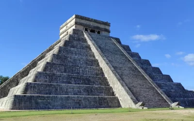
Before the arrival of the Spaniards in the Yucatan Peninsula, the name of this region was “Mayab” which in the Mayan language means not many or a few. It was a very important region for the Mayan Civilization, especially during the so-called post-classic period, although the most remote Mayan settlements in the region are estimated to date from the third century after Christ, when the first migrations from “El Petén” settled in the Bacalar region in the east of the Yucatan Peninsula. Around the fifth century, the settlers began to move to the west of the peninsula, founding, among other cities, Chichen Itza, Izamal, Motul, Balam and Tho. You can see these cities in “Map Yucatan”.
Many of the Maya cities of the Yucatan Peninsula region survived after the collapse of the cities of the original Maya region, and many of them were still inhabited when the Spanish arrived in the early sixteenth century.
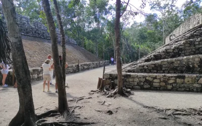
At present, many of the Mayan vestiges and ruins are preserved in good condition and a good number of Mayan archaeological sites are integrated into urban areas, which comprise various periods of the development of the Mayan Civilization, proof that these places have had a line of continuity in its existence throughout the centuries. You can see archaeologicarl sites in “Map Yucatan”.
From the Spanish conquest in the first part of the 16th century, and until the first decades of the 19th century, the Yucatan peninsula was made up of the current states of Campeche, Tabasco, Quintana Roo, Yucatan and what today constitutes northern Belize. It comprised a single political-administrative entity such as the Captaincy General of Yucatan. You can see it in “Map Yucatan”.
After the Independence of Mexico in 1823, a first republic of Yucatan was configured that joined the Federal Republic of the United Mexican States.
In 1841, as a result of cultural and political conflicts linked to the federal pact that had been broken, Yucatán declared its Independence from Mexico to constitute a second republic of Yucatán, but it would only last until 1848 when Yucatán returned to Mexico.
In the second half of the 17th century, the region of the Yucatan Peninsula experienced a civil war between the Mayan peoples and the authorities of the Republic of Yucatan that lasted more than 50 years.
In 1912, at the end of the caste war, the state of Yucatán was divided again to create the federal territory that would later become the current state of Quintana Roo. You can see Quintana Roo State in “Map Yucatan”.
There are several versions of the meaning in Yucatan Maya, although no objective confirmation has been achieved; One of the versions comes from Alonso de Zorita in his work on the new Spain in which he mentions the explorer Francisco Hernández de Córdoba In his 1517 expedition in which they went to a land not seen before by the Spanish where they found local settlers and they asked them what was the name of a large town that was nearby, to which the local Mayan settlers replied “Tectetam” which means “I don’t understand you” in Mayan, and the Spanish thought that the whole area was called that and corrupting the Word, they called it Yucatam.
Another version of the origin of the name of Yucatan comes from the encyclopedia of Yucatan at the time in which the brother of Christopher Colon “Bartholomew Colon” is mentioned, who was on a trade mission off the coast of what is currently es Honduras and after exchanging merchandise, the indigenous people pointed to the coasts of their land in the distance and said: “Yuk´ al-tan Mayab” which was the linguistic designation of their nation and what “all those who speak the Mayan language” means.
The first settlers in the Yucatan peninsula were the Mayans, although the presence of the first humans in the geographical space dates back to the end of the Pleistocene, as indicated by the findings in the caverns on the eastern coast of the peninsula and in the caves of Loltún. You can see Loltun in “Map Yucatán”.
Some historians affirm that the first Mayans arrived in the Yucatan Peninsula through the Petén region which is located southeast of the Yucatan Peninsula in the Quintana Roo Bacalar zone around the year 250 after Christ, the first people of the Mayans were called “the Chanes” They are the people that preceded the “Itzaes”, from the year 525 they begin to move north of the Yucatan Peninsula, they were the builders of Chichen Itza, Izamal Motul, Ek Balam, Tho (The city of Mérida) and Champotón. You can see it in “Map Yucatán”.
Later, the “Xiúes” of Toltec descent and who came from the coast of the Gulf of Mexico began to settle in the region, giving rise to the displacement of the transfers and the “Cocomes” who were a branch of the “Itzae” people.
Over the years and multiple confrontations, the Mayapán League would be formed, which was made up of the Itzaes, the Xiúes and the Cocomes, an alliance that brought stability to the Yucatán Peninsula that lasted until the year 1194, giving way to a period of anarchy and fragmentation in small manors with which the first Spanish conquerors met in the 16th century.
The first Spaniards to arrive at the Yucatan Peninsula did so on March 1, 1517 and it was Francisco Hernández de Córdoba with the participation of captains Cristóbal de Morante and Lope Ochoa de Caicedo, with the authorization of the governor of the island of Cuba Diego Velázquez of Cuellar.
The conquest of Yucatan was consummated 2 decades after the conquest of Mexico by Francisco de Montejo, his son also called Francisco de Montejo y León el Mozo and his nephew, also Francisco de Montejo the advanced had been in the expedition of Juan de Grijalva and He also participated with Hernán Cortés during the third expedition that finally became the conquest of Mexico. Francisco de Montejo was entrusted with the conquest of the Mayab, but failed in a first attempt between 1527 and 1528. Later he was appointed governor of Tabasco in 1529, with the royal mandate to pacify Tabasco and conquer the Yucatan Peninsula reaching the town from Santa María de la Victoria at that time capital of the province of Tabasco from where he began his mission.
Francisco de Montejo from Tabasco led a new campaign towards Yucatan between 1531 and 1535, failing again in his attempt and after many bloody battles with the Mayan inhabitants of the region around 1535 Francisco de Montejo achieved the total pacification of the province of Tabasco and He then began to plan his new incursion towards Yucatan.
After Francisco de Montejo the advanced took office in Honduras and later in Chiapas. For these responsibilities he conferred on his son his namesake also called Francisco de Montejo nicknamed the young man who founded the cities of San Francisco de Campeche and also Mérida in honor of the Merida of Extremadura Spain on the Mayan ruins of THo and using the stone available in the abandoned Mayan buildings for the construction of the city. You can see Merida in “Map Yucatan”.
Once the conquest was consummated, Francisco de Montejo was in charge of the government of Yucatan from 1546, but due to complaints received in the Spanish court he was dismissed from his position in 1550, returning to the metropolis to assume his own defense before the council of Indias, however, he died in Salamanca in 1553 before he could clear his name and his son Francisco de Montejo “El Mozo” died on February 8, 1565 in Guatemala after a long illness, while the nephew died in Mérida in 1572 being its alderman at the age of 55 years.
In November 1761, a social uprising took place in Yucatan that did not have great consequences for the colonial regime, although it definitely marked the history of the peninsula and clearly exposed the tensions that existed in the region as the product of inequity and prejudices in which the indigenous Mayans were held for the exclusive benefit of the white race and Spaniards that 100 years later would lead to the Caste War.
This rebellion took place in the town of “Cisteil” in which a Mayan leader named Jacinto Canek took up arms together with a group of indigenous people against the Spanish colonial government. Although the rebellion was put down and the rebels captured, summarily tried and tormented in Mérida and the town of Cisteil, burned and covered with salt to scare the population, the event produced such social unrest that it marked a milestone in Yucatecan history that until the date is remembered as a symbol of the racial and social struggle that existed for centuries.
After independence was proclaimed in Mexico, Yucatan was not affected militarily by the Mexican War of Independence since the Yucatan region was far from the center of Mexico, which was the place where the hostilities for the independence war took place, but already There was a liberating spirit in the enlightened Yucatecans represented by the “Sanjuanistas” who ideologically confronted the conservative faction of Yucatecan society represented by the group called the “Rutineros”. In 1820 the patriotic confederation was founded by Lorenzo de Zavala one of the Sanjuanistas and there was a moment of rupture as there were those who supported the Spanish government and the Cadiz constitution of 1812 while the other group led by Zavala sought absolute independence from Spain.
While this was happening in Yucatán, the plan of Iguala was proclaimed in Mexico and the treaties of Córdoba were signed, after which Juan María Echeverri, the last representative of Spain in the government of Yucatán, proclaimed the independence of the Yucatán Peninsula and sent 2 representatives to negotiate the incorporation of Yucatan into insurgent Mexico. The incorporation into the first Mexican empire occurred on November 2, 1821. On December 23, 1823, it was one of the 19 free and sovereign states that would found the current Mexican nation in accordance with the provisions of the Mexican constitution of 1824.
In 1835, the Yucatan Republic emerged, proclaiming its independence from Mexico as a response to the centralist governments in Mexico that violated the federal pact that Yucatan had signed in 1825, the Republic of Yucatan maintained relative independence for 8 years but was forced to rejoin to the Mexican nation in 1848 because it had carved a civil war called the caste war and Mexico had conditioned its military support to the government of Yucatan.
In 1852, the state of Yucatan was divided by Campeche initiative due to internal struggles between opposing political factions aggravated by the consequences of the caste war. You can see Campeche in “map Yucatán”.
The caste war that began in 1847 was a bloody movement led by the Mayan chiefs Jacinto Pat and Cecilio Chi with the aim that the Mayans subjected for 3 centuries will regain their freedom and independence, this movement was known as the caste war and was lasted for more than half a century. During many years of struggle between local and federal troops and indigenous groups, as none of the parties to the conflict seemed to achieve victory over the enemy, during this stage the foundation of a new capital in the jungle took place by the Mayans as they called “Nooj Kaaj Santa Cruz (today Felipe Carrillo Puerto)”. You can see Felipe Carrillo Puerto in “Map Yucatan”.
The last important action of the caste war was the siege that the Mayans imposed on “Tijosuco” for 50 days in 1865, the definitive surrender of the Mayans was achieved by General Ignacio Bravo, who in 1899 occupied the military leadership of Yucatan, the General Bravo undertook a gradual advance and consolidated all the positions gained, until he definitively occupied “Chan Santa Cruz” in May 1901, with which the peninsula was under the direct control of the federal government, it would be a year later when Yucatan would suffer the second territorial change, by decreeing the creation of the federal territory of Quintana Roo with capital in the port of “Payo Obispo” today “Chetumal” with this, after half a century of war, Yucatan would have been dismembered losing more than 2/3 parts of its original territory. You can see it in “Map Yucatan.
At the same time that the caste war was developing in the mid-nineteenth century, a henequen agroindustry temporarily supported the autarchy of Yucatan, since the henequen plant was the basis of a solid and dynamic economy that underpinned the economic development of the state, although unfortunately not so its social development, the products derived from henequen such as rigging, ropes, sacks, rugs, coatings and many others how they became export items from the Yucatan Peninsula and brought the foreign exchange and resources required to finance the growth of the state, the state of Yucatán experienced growth during the last years of the 19th century thanks to the henequen industry, although part of its economic success was based on the exploitation of the workforce provided by the indigenous Mayans. This success lasted until the end of the Second World War when henequen products lost relevance due to the arrival of synthetic products.
The boom situation allowed the city of Mérida to have electric public lighting and trams before Mexico City. At the beginning of the 20th century Mérida had a greater number of millionaires per capita than any other part of Latin America and for this reason Parisian boulevards and luxurious houses of the time can be found in “Paseo de Montejo” while the populations in the interior of Yucatan suffered from shortages. You can see Paseo de Montejo in “Map Yucatán”.
In the 1930s there was contact by air through seaplanes that took off from the swamp of the Progreso Yucatán Port heading to Havana, Cuba, and Florida in the United States. In the following decade, with the inauguration of the air terminal, it was possible to connect with Mexico City through the then Mexicana aviation company.
In 1951 Yucatan was able to join the rest of the country by rail, although with incompatibility of railways, since from the south of Veracruz to the peninsula the narrow gauge system prevailed for some years, unlike the wide gauge that existed in Veracruz. towards the altiplano, later in the 80s the highway would arrive that finally connected the altiplano with the Yucatan Peninsula. You can see it in “Map Yucatan”.
In the last decade of the 20th century, a process of economic and social reorganization was successfully conducted that has allowed the entity to leave the dependency in general, which had already exhausted its capacity to be the fundamental axis of economic development.
Merida Yucatan
Merida Yucatán is the capital and most populous city of the state of Yucatán in Mexico, it is located in the northwest of the state in the southeastern region of the country, where it is the main social, cultural, educational and financial center. You can see it in “Map Yucatan”.
According to the last census carried out in 2020, the city of Merida Yucatan has a population about 921,000 inhabitants. Mérida is considered one of the cities with the best life quality in Mexico and one of the safest in the American continent.
The historical heritage of Merida is the product of the mixture of the Mayan, Spanish and African cultures during the colonial era, later influenced by the French and Lebanese cultures with some contributions from the Dutch, Korean and Italian, thanks to its rich cultural heritage Merida was the first city to be named the American capital of culture and the first to receive this title twice.
The Mérida historic center is the third largest in the continent and the San Idelfonso Cathedral, located in front of the main square and built with stones from adjacent Mayan ruins, is the oldest in continental America.
Forbes magazine has classified Mérida on 3 occasions as one of the 3 best cities in Mexico to live and invest, the Mexican Institute for Competitiveness has cataloged Mérida as one of the 3 most competitive cities in Mexico for its infrastructure and high social standards, one of the cities often chosen as the venue for several international events; Merida Yucatan has hosted 2 meetings between the United States and Mexico, a meeting with Cuba, a summit of the Nobel Peace Prize, and summits of the Association of Caribbean States and the Pacific Alliance. In addition, several international scientific Olympiads have been held in Mérida, such as the Physics, Mathematics and Computer Science Olympiad. Every year the Yucatan International Reading Fair of the Autonomous University of Yucatan is held in Merida. You can see it in “Map Yucatan”.
The city of Mérida was named in honor of the Merida city of Spain and was founded in 1542 by Francisco de Montejo on the remains of the Mayan city of “THO” that was uninhabited when the Spanish conquerors arrived.
The city of Mérida is located within the so-called “chicxulub crater” formed, according to the most accepted hypothesis, by the impact of an asteroid 65 million years ago, an event known as the impact that would have caused the mass extinction of the Cretaceous-Paleogene in the which the dinosaurs disappeared among other species, the size of the “chicxulub crater” is about 180 km in diameter and around the crater is what is known as “the ring of cenotes”. Merida is located at a distance of 309 km from Cancun and 1557 km from Mexico City. You can see Cancun it in “Map Yucatan”.
Weather in Merida Yucatan
The climate in Merida is warm, humid tropical, with rains in summer and with an average monthly temperature of 25 °C and it is located in the dry forest ecosystem.
Attractions in Merida Yucatan
Within Merida Yucatan there are many attractions for visitors such as the historic center of Merida, which stands out for being the third largest in the American continent only after the historic center of Mexico City and the historic center of Old Havana in Cuba. It was declared a national heritage in 1986 by decree of former Mexican President José López Portillo, the area includes a remarkable monumental and architectural heritage from between the 16th and 19th centuries. You can see it in Map Yucatan.
In Mérida there are also many Mayan archaeological remains, the closest archaeological sites to the capital city are Dzibilchaltún, Dzoyilá, Chen Hó, Flor de Mayo, Xcatzmil, Caucel and Xoclán, among others.
Within Merida, several haciendas dating from the 19th century are also preserved, which were dedicated to the henequen industry and were part of the network of haciendas that integrated the great industry in general in the region; There are haciendas that have been completely rebuilt and fitted out as museums, hotels, tourist inns or social event rooms. You can see it in “Map Yucatan”.
Architecture in Merida Yucatan
The center of Mérida keeps the colonial configuration of the city, which is an area of approximately 4 km² that contains the oldest buildings in the city, including the first square where the central square is located, called the large square or main park in which is the cathedral, the government palace, seat of the executive power of the state and the municipal palace. There are other important buildings that stand out, such as the house of Montejo, where the conquerors of Yucatan and founders of Mérida lived in the 19th century. You can see Paseo de Montejo in “Map Yucatan”.
Paseo de Montejo (Montejo Walk)
Paseo de Montejo (Montejo Walk) is the most important avenue in the city, it extends from the neighborhood of Santa Ana in the center of the city, to the exit to the port of “Progreso” the layout and design of the Paseo de Montejo are inspired by French boulevards as it is flanked by large trees, has a median and numerous roundabouts; On both sides of the Paseo de Montejo, large French-style mansions were built during the boom in the genre that Yucatán had at the end of the 19th century and the beginning of the 20th century. You can see these buildings in “Map Yucatan”.
Merida Mexico Beaches
The closest beaches to Mérida can be found in the “ Puerto Progreso(Progreso Port)”, about 40 minutes from the city, and the beaches of Celestun and Telchak port are also relatively close. You can see Merida Mexico beaches in “Map Yucatan”.
Economy in Merida Yucatan
In the middle of the 19th century Merida Yucatan was one of the most important worldwide centers of henequen trade, a plant that is of the agave type which was a very important raw material for the international textile industry.
This produced an incredible level of wealth that would soon become apparent both in the city of Mérida and in the large agricultural estates known as haciendas that spread throughout the Yucatan Peninsula.
As of 1938 with the invention of nylon, the henequen companies began to go bankrupt, with which the economy of Mérida collapsed and had to readapt for half a century to a totally different economic reality.
Currently, the economy of Mérida is focused mainly on economic activities in the tertiary sector, it is quite robust with one of the lowest unemployment rates in Mexico, Mérida ranks thirteenth among the most visited destinations in Mexico, so the tourism industry it is one of the most important for the city, which has strongly attracted the investment of different national and foreign companies in the region; The safe environment and high social standards that have characterized the city over time have also made it a very attractive and ideal place for investment by companies in the real estate sector.
Real Estate in Merida Mexico
The real estate in merida mexico and homes for sale in merida mexico for inhabitants of other countries has increased considerably, especially due to the boom in investments in physical goods and fixed assets as a consequence of the increase in inflation in OECD countries. from 2019 and the Pandemic from 2020.
Also in Playa del Carmen and Cancun you can find many “Real Estate” companies with extensive portfolios of land, houses, apartments and luxury villas.
Merida Yucatan History
Merida Yucatán was founded on January 6, 1542 by the Spanish Francisco de Montejo and 100 Spanish families after the Spanish conquered the capital of the “Aztecas” the city of “Tenochtitlan”. During the colonial era, part of the city’s architecture corresponding to the 17th and 18th centuries can be seen in the city center. During this period, in order to protect the city from Mayan uprisings, a walling plan was proposed, of which only the wall surrounding the city with the entrances or arches was carried out, currently only the arch of the “Barrio De San Juan” is preserved, the arches of dragons and the bridge in the neighborhood of “La Mejorada”. You can see it in Map Yucatan.
After Mexican independence during the 19th century and the beginning of the 20th century, there was a process of Frenchification of urban architecture that was reflected in the old mansions built at that time on Paseo de Montejo, many of which still exist.
The main economic source of Mérida at the end of the 19th century was the henequen industry, the so-called “green gold”, which made Mérida have a boom situation that allowed the city to have electric public lighting and trams before many other cities in the world Mexico.
At the beginning of the 20th century Mérida had a large number of wealthy families that contrasted with a widespread poverty of the indigenous population.
The Paseo de Montejo is an avenue built at that time and inspired by the great boulevards of Paris, in Paseo de Montejo the mansions of the wealthy henequen landowners were built. You can see it in “Map Yucatan”.
In this days the human development index of Mérida Yucatan is considered high with a score of 0.8940.
The population of Mérida is predominantly Catholic although there is also a presence of other religions such as the Adventists, the Orthodox Church, Jehovah’s Witnesses, the Baptist Church, the Presbyterian Church, Light of the World and other independent evangelical churches.
In the year 2000 the Catholic population in Merida amounted to 553,000 inhabitants while non-Catholics numbered 80,714 inhabitants; In 1993 Pope John Paul visited Merida on his third visit to Mexico.
VIVA MEXICO !


“Chicxulub Crater” fixed by an asteroid 65 million years ago and to which the extinction of the dinosaurs is attributed.
The port of Chicxulub is the closest town to the epicenter of the “Chicxulub Crater” fixed by an asteroid 65 million years ago and to which the extinction of the dinosaurs is attributed. As a consequence of the impact in Chicxulub, a network of caves known as cenotes was created around which is the so-called ring of cenotes, it is estimated that there are more than 3000 cenotes in the Yucatecan territory

See amazing Tours available in Riviera Maya
Related Articles

Mayan Train Map
Mayan Train Map You can click on extend screen on the “Mayan Train Map” to use the map in fullscreen and be able to filter the sites by map categories such as Mayan Train Route (under construction) highlighted in Yellow, ATMs, gas stations, energy stations for...
Yucatan Peninsula Map
Yucatan Peninsula Map You can click on extend screen on the “Yucatan Peninsula Map” to use the map in fullscreen and be able to filter the sites by map categories such as ATMs, gas stations, energy stations for electric vehicles, archaeological sites, Hospitals,...
Quintana Roo Mexico Map
Quintana Roo Mexico Map You can click on extend screen on the “Quintana Roo Mexico Map” to use the map in fullscreen and be able to filter the sites by map categories such as ATMs, gas stations, energy stations for electric vehicles, archaeological sites, Hospitals,...
Recomended tours to Yucatan

Tour to Chichen Itza
Private tour from Cancun or Riviera Maya to the Yucatan Peninsula. Ancient ruins and pyramids, colonial cities, cenote and Tequila Factory. Mexico Tours.
Trip Duration: 9-10 hours
Transportation: Included
Tourist Guide: Included

Ek Balam
Trip Duration: 9-10 hours
Transportation: Included
Tourist Guide: Included

Private Mini Yucatan: Chichen Itzá, Uxmal, cenote, Mérida and Izamal + Tequila & Chocolate factory Factory (2 days)
Ancient Mayan cities and cenotes, Tequila factory and the colonial cities of Merida & Izamal. Mexico Tours
Trip Duration: 2 days 1 Nigth
Breakfast: Not Included
Stay Up to Date With The Latest News & Updates
Follow Us
Follow us to be updated about useful content in Riviera Maya
