


Merida Yucatan Map
You can click on extend screen on the “Merida Yucatan Map” to use the map in fullscreen and be able to filter the sites by map categories such as ATMs, gas stations, energy stations for electric vehicles, archaeological sites, Hospitals, Mayan train route in construction, Merida cenotes, services and “things to do in merida mexico” and things to do throughout the Yucatan Peninsula, Merida Restaurants, Merida mexican grill, Merida Mexico Beaches and Mayan Ruins like Uxmal, Mayapan, Kabah and others.
Merida Yucatan
Merida Yucatán is the capital and most populous city of the state of Yucatán in Mexico, it is located in the northwest of the state in the southeastern region of the country, where it is the main social, cultural, educational and financial center.
According to the last census carried out in 2020, the city of Merida Yucatan has a population about 921,000 inhabitants. Mérida is considered one of the cities with the best life quality in Mexico and one of the safest in the American continent.
The historical heritage of Merida is the product of the mixture of the Mayan, Spanish and African cultures during the colonial era, later influenced by the French and Lebanese cultures with some contributions from the Dutch, Korean and Italian, thanks to its rich cultural heritage Merida was the first city to be named the American capital of culture and the first to receive this title twice.
The Mérida historic center is the third largest in the continent and the San Idelfonso Cathedral, located in front of the main square and built with stones from adjacent Mayan ruins, is the oldest in continental America.
Forbes magazine has classified Mérida on 3 occasions as one of the 3 best cities in Mexico to live and invest, the Mexican Institute for Competitiveness has cataloged Mérida as one of the 3 most competitive cities in Mexico for its infrastructure and high social standards, one of the cities often chosen as the venue for several international events; Merida Yucatan has hosted 2 meetings between the United States and Mexico, a meeting with Cuba, a summit of the Nobel Peace Prize, and summits of the Association of Caribbean States and the Pacific Alliance. In addition, several international scientific Olympiads have been held in Mérida, such as the Physics, Mathematics and Computer Science Olympiad. Every year the Yucatan International Reading Fair of the Autonomous University of Yucatan is held in Merida.
The city of Mérida was named in honor of the Merida city of Spain and was founded in 1542 by Francisco de Montejo on the remains of the Mayan city of “THO” that was uninhabited when the Spanish conquerors arrived.
The city of Mérida is located within the so-called “chicxulub crater” formed, according to the most accepted hypothesis, by the impact of an asteroid 65 million years ago, an event known as the impact that would have caused the mass extinction of the Cretaceous-Paleogene in the which the dinosaurs disappeared among other species, the size of the “chicxulub crater” is about 180 km in diameter and around the crater is what is known as “the ring of cenotes”. Merida is located at a distance of 309 km from Cancun and 1557 km from Mexico City. You can see Cancun it in Merida Yucatan Map.
Weather in Merida Yucatan
The climate in Merida is warm, humid tropical, with rains in summer and with an average monthly temperature of 25 °C and it is located in the dry forest ecosystem.
Attractions in Merida Yucatan
Within Merida Yucatan there are many attractions for visitors such as the historic center of Merida, which stands out for being the third largest in the American continent only after the historic center of Mexico City and the historic center of Old Havana in Cuba. It was declared a national heritage in 1986 by decree of former Mexican President José López Portillo, the area includes a remarkable monumental and architectural heritage from between the 16th and 19th centuries.
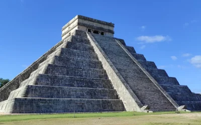
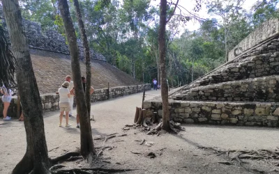
In Mérida there are also many Mayan archaeological remains, the closest archaeological sites to the capital city are Dzibilchaltún, Dzoyilá, Chen Hó, Flor de Mayo, Xcatzmil, Caucel and Xoclán, among others.
Within Merida, several haciendas dating from the 19th century are also preserved, which were dedicated to the henequen industry and were part of the network of haciendas that integrated the great industry in general in the region; There are haciendas that have been completely rebuilt and fitted out as museums, hotels, tourist inns or social event rooms.
Architecture in Merida Yucatan
The center of Mérida keeps the colonial configuration of the city, which is an area of approximately 4 km² that contains the oldest buildings in the city, including the first square where the central square is located, called the large square or main park in which is the cathedral, the government palace, seat of the executive power of the state and the municipal palace. There are other important buildings that stand out, such as the house of Montejo, where the conquerors of Yucatan and founders of Mérida lived in the 19th century. You can see Paseo de Montejo in “Merida Yucatan Map”.
Paseo de Montejo (Montejo Walk)
Paseo de Montejo (Montejo Walk) is the most important avenue in the city, it extends from the neighborhood of Santa Ana in the center of the city, to the exit to the port of “Progreso” the layout and design of the Paseo de Montejo are inspired by French boulevards as it is flanked by large trees, has a median and numerous roundabouts; On both sides of the Paseo de Montejo, large French-style mansions were built during the boom in the genre that Yucatán had at the end of the 19th century and the beginning of the 20th century. You can see these buildings in “Merida Yucatan Map”.
Merida Mexico Beaches
The closest beaches to Mérida can be found in the “ Puerto Progreso(Progreso Port)”, about 40 minutes from the city, and the beaches of Celestun and Telchak port are also relatively close. You can see Merida Mexico beaches in “Merida Yucatan Map”.
Economy in Merida Yucatan
In the middle of the 19th century Merida Yucatan was one of the most important worldwide centers of henequen trade, a plant that is of the agave type which was a very important raw material for the international textile industry.
This produced an incredible level of wealth that would soon become apparent both in the city of Mérida and in the large agricultural estates known as haciendas that spread throughout the Yucatan Peninsula.
As of 1938 with the invention of nylon, the henequen companies began to go bankrupt, with which the economy of Mérida collapsed and had to readapt for half a century to a totally different economic reality.
Currently, the economy of Mérida is focused mainly on economic activities in the tertiary sector, it is quite robust with one of the lowest unemployment rates in Mexico, Mérida ranks thirteenth among the most visited destinations in Mexico, so the tourism industry it is one of the most important for the city, which has strongly attracted the investment of different national and foreign companies in the region; The safe environment and high social standards that have characterized the city over time have also made it a very attractive and ideal place for investment by companies in the real estate sector.
Real Estate in Merida Mexico
The real estate in merida mexico and homes for sale in merida mexico for inhabitants of other countries has increased considerably, especially due to the boom in investments in physical goods and fixed assets as a consequence of the increase in inflation in OECD countries. from 2019 and the Pandemic from 2020.
Also in Playa del Carmen and Cancun you can find many “Real Estate” companies with extensive portfolios of land, houses, apartments and luxury villas.
Merida Yucatan History
Merida Yucatán was founded on January 6, 1542 by the Spanish Francisco de Montejo and 100 Spanish families after the Spanish conquered the capital of the “Aztecas” the city of “Tenochtitlan”. During the colonial era, part of the city’s architecture corresponding to the 17th and 18th centuries can be seen in the city center. During this period, in order to protect the city from Mayan uprisings, a walling plan was proposed, of which only the wall surrounding the city with the entrances or arches was carried out, currently only the arch of the “Barrio De San Juan” is preserved, the arches of dragons and the bridge in the neighborhood of “La Mejorada”.
After Mexican independence during the 19th century and the beginning of the 20th century, there was a process of Frenchification of urban architecture that was reflected in the old mansions built at that time on Paseo de Montejo, many of which still exist.
The main economic source of Mérida at the end of the 19th century was the henequen industry, the so-called “green gold”, which made Mérida have a boom situation that allowed the city to have electric public lighting and trams before many other cities in the world. Mexico.
At the beginning of the 20th century Mérida had a large number of wealthy families that contrasted with a widespread poverty of the indigenous population.
The Paseo de Montejo is an avenue built at that time and inspired by the great boulevards of Paris, in Paseo de Montejo the mansions of the wealthy henequen landowners were built.
In this days the human development index of Mérida Yucatan is considered high with a score of 0.8940.
The population of Mérida is predominantly Catholic although there is also a presence of other religions such as the Adventists, the Orthodox Church, Jehovah’s Witnesses, the Baptist Church, the Presbyterian Church, Light of the World and other independent evangelical churches.
In the year 2000 the Catholic population in Merida amounted to 553,000 inhabitants while non-Catholics numbered 80,714 inhabitants; In 1993 Pope John Paul visited Merida on his third visit to Mexico.
VIVA MEXICO !


The henequen was the “green gold” in Yucatan, which made Mérida had a boom situation
The main economic source of Mérida at the end of the 19th century was the henequen industry, the so-called “green gold”, which made Mérida have a boom situation that allowed the city to have electric public lighting and trams before many other cities in the world. Mexico.

See amazing Tours available in Riviera Maya
Related Articles

Mayan Train Map
Mayan Train Map You can click on extend screen on the “Mayan Train Map” to use the map in fullscreen and be able to filter the sites by map categories such as Mayan Train Route (under construction) highlighted in Yellow, ATMs, gas stations, energy stations for...
Yucatan Peninsula Map
Yucatan Peninsula Map You can click on extend screen on the “Yucatan Peninsula Map” to use the map in fullscreen and be able to filter the sites by map categories such as ATMs, gas stations, energy stations for electric vehicles, archaeological sites, Hospitals,...
Quintana Roo Mexico Map
Quintana Roo Mexico Map You can click on extend screen on the “Quintana Roo Mexico Map” to use the map in fullscreen and be able to filter the sites by map categories such as ATMs, gas stations, energy stations for electric vehicles, archaeological sites, Hospitals,...
Recomended tours to Merida

Private Mini Yucatan: Chichen Itzá, Uxmal, cenote, Mérida and Izamal + Tequila & Chocolate factory Factory (2 days)
Ancient Mayan cities and cenotes, Tequila factory and the colonial cities of Merida & Izamal. Mexico Tours
Trip Duration: 2 days 1 Nigth
Breakfast: Not Included
Stay Up to Date With The Latest News & Updates
Follow Us
Follow us to be updated about useful content in Riviera Maya
