


Cancun Map
You can click on extend screen on the “Cancun Map” to use the map in fullscreen and be able to filter the sites by map categories such as ATMs, gas stations, energy stations for electric vehicles, archaeological sites, Hospitals, Cancun Beaches, Mayan train route in construction, cancun cenotes and cenote from cancun, services and “cancun things to do” and things to do throughout the Yucatan Peninsula, cancun menú, cancun mexican grill, snorkeling cancun and tours of cancun.
Cancun
Cancun means “nest of snakes” in Mayan, Cancun is located in eastern Mexico approximately 1,600 km from Mexico City, Cancun is located in the Mexican state of Quintana Roo.
Cancun is the largest city in Quintana Roo with 888,797 inhabitants according to the 2020 population census. Cancun is considered a world-class tourist destination by the World Tourism Organization.
Cancún began operations in 1974 as a tourist center planned by FONATUR.
Cancun has undergone a remarkable transformation since 1974, Cancun was previously considered a fishing village.
Cancun is the main tourist destination in Mexico along with Mexico City and the Riviera Maya, in addition, the Cancun international airport is the second with the most movement of passengers, which makes Cancun the main tourist destination in Mexico.
Cancun will also be within the Railway Network under construction called “the Mayan Train” you can see it on the Cancun Map highlighted in yellow.
The Mayan Train is a megaproject that has been underway since December 2018 in southeastern Mexico. It is planned as a regional train for locals, tourists and cargo, is planned to begin operations in early 2024.
The Mayan Train line starts in palenque chiapas and travels northeast towards Cancún in Quintana Roo through 2 routes that circle the yucatan peninsula the project aims to connect tourist destinations in the caribbean with lesser known sites inland, including mayan sites history from which it derives its name. you can see it on the Cancun Map highlighted in yellow.
Cancun is divided into 5 zones, the first and the most important touristically is Cancun Island, which is where the hotel zone of Cancun is located, in addition to being the area where most of the beaches and tourist activities are concentrated; the second area of Cancun is the urban area which is where the bulk of the population lives; The third zone is Puerto Juárez, which is the place where the 2 main docks are located to embark and cross to Isla Mujeres, located just 7 km from the port; The fourth area of Cancun is called the Ejidal Strip, which is an area of irregularly distributed settlements in the northern part of the city in the municipal limits of Isla Mujeres and Alfredo Bonfil.
Cancun is located northeast of the Yucatan peninsula and from Cancun you can clearly see Isla Mujeres to the north of the city in the so-called women’s fence, which is the area through which various boats and boats-cross that transport the inhabitants all day from the island to the mainland.
The hotel zone is the most important tourist area in Cancun since it is where most of the beaches and tourist activities for which the destination is recognized are concentrated, Cancun Island is a strip of land in the shape of a number 7 with a length of 23 km. you can see map of cancun hotel zone on the Cancun Map.
Isla Cancún houses most of the hotels and beaches, as well as residential areas such as Isla Dorada, the Poktapok golf course and the entrance to the exclusive area of Puerto Cancún, which is the most ambitious and important residential area in the city, Isla Cancún is united to the mainland by 3 bridges: the calinda bridge, the club med bridge, and the nizuc bridge, you can see it on the Cancun Map.
In the urban area of Cancun is where the bulk of the population of Cancun lives and is divided into neighborhoods, subdivisions, superblocks or regions such as the regular ones perfectly delimited by paved streets and avenues that have basic services of electricity, drinking water, telephone service, sanitation and internet. In the urban area of Cancun is where most of the city’s political, educational, cultural and service institutions are located.
The Cancun City increases in size every year due to the growth it has experienced since its inception which has continued to this day, so that the zone of the Ejidal strip of Cancun each year has new housing and infrastructure projects such as subdivisions , residential, and new neighborhoods where visitors from all over Mexico and other parts of the world arrive every year to look for their new home in Cancun.
Another area of Cancun is Alfredo Bonfil, which is one of the 3 delegations of the municipality of Benito Juárez, the population of Alfredo Bonfil originally started with settlers from the north of Mexico with the mission of contributing to the demographic increase of Quintana Roo to reach the category of free and sovereign state in 1974 and is located 8 km from downtown Cancun on the federal highway that goes to the international airport and the Riviera Maya, you can see it on the Cancun Map.
Weather in Cancun
The climate in Cancun is characterized by the influence of hot ocean currents because Cancun is located on the eastern coast of the continent, which favors a warm and rainy climate.
The predominant climate in Cancun is warm sub-humid with frequent rains during the year, although more abundant in summer. The average temperature in Cancun is between 25° Celsius and the hurricane season begins in mid-June.
December weather in cancun:
The December weather in Cancun is pleasant with an average temperature of 26.8 degrees Celsius and little rain.
Flora in Cancun
The vegetation in Cancun is characterized by being medium forest, lowland forest, lowland flooded forest, mangrove savannah, flooded palm grove and coastal dune vegetation.
In the center between the island of Cancun and the urban area of Cancun we find the enormous Nichupte Lagoon in which we can find species of flora characteristic of the region such as the acacia, the annona, baleno, cameraria latifolia, the palm, the coconut, the dyewood, sapodilla, chechén, pouteria chiricana, palm, red mangrove, and chit palm, you can see the Nichupte Lagoon on the Cancun Map.
Wildlife in Cancun
Given the diversity of flora that exists in Cancun and its surroundings, this ecosystem makes it possible for there to be a great diversity of fauna in Cancun and its surroundings, such as many varieties of crustaceans, oysters, various species of fish such as cyclic fish and cyclic poe fish, the American eel; We can also find bird species in Cancun such as the blue-winged egret, the carao, the squacco hawk, the hocofaisán, the heron, the palomero falcon, the long-legged hawk, the Yucatecan bolsero, the curculado bolsero, the king vulture, the swallow marina, the ocellated turkey, the Yucatecan parrot and the Mexican Zanate.
Turtles such as the loggerhead, the white turtle, the leatherback turtle, and the sea turtle reproduce in the Cancun area, as well as the boa constrictors, like the grated hollow, like the garrobo, the green iguana, the howler monkey, the spider monkey, the manatee and the crocodile.
Cancun History
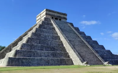
During pre-Hispanic times, the Mayans maintained a commercial network from the Terminos lagoon to Honduras, for which they established maritime routes that ran along the entire coast of the current state of Quintana Roo. For this reason, the Mayans built buildings along the Caribbean Sea along Cancun and the Riviera Maya to carry out commercial exchanges, monitor and help navigation.
According to archaeological studies carried out in the archaeological site of El Meco and the archaeological site of El Rey, which were inhabited points until the 16th century, in the chronicles of the Indies a locality with the name of Velma is described, it is probable that this locality corresponds to the archaeological site of “El Meco” you can see it on the Cancun Map.
The first Spanish Navigator to explore Cancún and Isla Mujeres was Francisco Hernández de Córdoba in 1517.
The first known map of Cancun was made by cartographer Juan de Dios González in 1776. During the 19th century, Cancun was visited by other Navigators such as Joan Loyd Stephens, Frederick Catherwood and Captain Richard Owen Smith.
Starting in 1967, INFRATUR decided to carry out a master plan in Cancun with the aim of building a world-class tourist destination as an engine to contribute to the Mexican economy.
Cancun has been the venue for various international forums due to its privileged location. In 1981 Cancun was the venue for the International Meeting on Cooperation and Development; in 1983 Cancun hosted a meeting of the accounting group that achieved the peace plan in Central America and the Caribbean; in 1989 Cancún was the seat of the miss universe beating Tel Aviv and Viña del Mar that also competed for the seat; In 2003, the Fifth Ministerial Conference of the World Trade Organization was held in Cancun.
Cancun has very safe infrastructures against hurricanes as a result of the impact of hurricanes Gilberto and Wilma, as proof of this, all the hurricanes that have impacted Cancun after Willma have not caused serious damage.
Cancun International Airport
Cancun International Airport is the one that receives the most international traffic in all of Mexico.
Cancun International Airport is the second largest air terminal in Mexico after the international airport of Mexico City, today the Cancun international airport has 2 runways and a considerable number of flights operate, it has a new control tower that is the tallest in Latin America and it is number 18 worldwide, Terminal 3 in Cancun is recently built and was created with energy savings in mind, you can see Cancun Airport on the Cancun Map.
Cancun Transport Services
Cancun has a huge variety of urban transport which greatly speeds up mobility in the urban area and in the hotel zone such as autocar, turicun and maya caribe; It also has land transportation to other cities in the Yucatan Peninsula through the ADO bus stations among other stations.
Cancun is also home to various television, radio, internet and print media outlets such as sipse TV, Cancun, channel 10, turquoise radio, the Quintana Roo system of social communication, pirate fm, radio formula QR, caribbean fm, among many other media.
Demographics in Cancun
Cancun is a cosmopolitan city due to its recent creation and development, which has caused that until today there is a mix of inhabitants from different cultures and regions of Mexico and other countries of the world due to the numerous job offers that it presents in tourist spaces.
In Cancun, the folklore, gastronomy and customs that prevail come from the neighboring state of Yucatan and the Mayan culture due to the location of Cancun.
Cancun is a multicultural city due to the mixture of cultures from different countries that inhabit the city, as it has a strong influence from countries such as Cuba, Puerto Rico, South Korea, countries in Europe, Africa, the United States, Canada, China, Russia, Japan and several Latin American countries such as Argentina, Colombia and Venezuela.
Religions in Cancun
Cancun is the city where the main religions of the municipality are concentrated, where the Catholic religion covers approximately 50% of the population. We can also find the presence of other religions such as Protestants, Presbyterians, Baptists, Methodists, Pentecostals, Neo-Pentecostals, Adventists, Mormons, Jehovah’s Witnesses, Jews and other religions.
VIVA MEXICO !


The Mayans maintained a commercial network from the Terminos lagoon to Honduras
During pre-Hispanic times, the Mayans maintained a commercial network from the Terminos lagoon to Honduras, for which they established maritime routes that ran along the entire coast of the current state of Quintana Roo. For this reason, the Mayans built buildings along the Caribbean Sea along Cancun and the Riviera Maya to carry out commercial exchanges, monitor and help navigation.

See amazing Tours available in Riviera Maya
Related Articles

Mayan Train Map
Mayan Train Map You can click on extend screen on the “Mayan Train Map” to use the map in fullscreen and be able to filter the sites by map categories such as Mayan Train Route (under construction) highlighted in Yellow, ATMs, gas stations, energy stations for...
Yucatan Peninsula Map
Yucatan Peninsula Map You can click on extend screen on the “Yucatan Peninsula Map” to use the map in fullscreen and be able to filter the sites by map categories such as ATMs, gas stations, energy stations for electric vehicles, archaeological sites, Hospitals,...
Quintana Roo Mexico Map
Quintana Roo Mexico Map You can click on extend screen on the “Quintana Roo Mexico Map” to use the map in fullscreen and be able to filter the sites by map categories such as ATMs, gas stations, energy stations for electric vehicles, archaeological sites, Hospitals,...
Recomended tours to Cancun

Whale Sharks Cancun
The whale sharks cancun tour is a very awesome tour in mexico for ecotourism lovers. you will experience one of the most impressive species of nature the whale shark
Trip Duration: 7 to 8 hours
Transportation: Included
Tour guide in English: Included
Breakfast, meals & soft drinks: Included
Stay Up to Date With The Latest News & Updates
Follow Us
Follow us to be updated about useful content in Riviera Maya
