


Beach Playa del Carmen Map
You can click on extend screen on the “Beach Playa del Carmen Map” to use the map in fullscreen and be able to filter the sites by map categories such as ATMs, gas stations, energy stations for electric vehicles, archaeological sites, Hospitals, Mayan train route in construction, cenotes Playa del Carmen, services and “what to do in playa del carmen” and things to do throughout the Yucatan Peninsula, Playa del Carmen Restaurants, Playa del Carmen mexican grill, Playa del Carmen Beaches and Ruins Tulum, Coba and others.
Playa del Carmen
Playa del Carmen is a Mexican city located in the state of Quintana Roo with an approximate population of 304,100 inhabitants according to the last census of the year 2020.
Playa del Carmen is located within the tourist area called Riviera Maya with a coast on the Caribbean Sea, the main economic activity in Playa del Carmen is tourism.
Playa del Carmen has had a great growth as a city since only 10,000 inhabitants lived in Playa del Carmen in 1996; In 2003 there were already 40,000 inhabitants, compared to the current ammount of approximately 300,000 inhabitants, it is a rapid growth compared to other cities from Mexico. In the same way, the Real Estate Playa del Carmen and houses in mexico for sale for inhabitants of other countries have increased considerably, especially due to the boom in investments in physical goods and fixed assets as a consequence of the increase in inflation in the “OECD” countries since 2019 and the Pandemic since 2020.
Playa del Carmen Meaning:
In pre-Hispanic times Playa del Carmen was called “Xaman há” which means “water from the north” in the Mayan language and was a starting point for the Mayan pilgrimage to the sanctuary of the Goddess Ixchel in Cozumel.
Economy Playa del Carmen
Playa del Carmen is one of the most visited places in the Riviera Maya so that tourism is the most important economic activity, making the rest of the economy depend directly or indirectly on this activity, also Playa del Carmen has a connection to other attractions related to ecotourism due to its location such as Xcaret, Xplor, Cozumel, Tulum, Xelha, Sian Ka an and Cancun You can see all these sites it in the Beach Playa del Carmen Map.
The highway Cancun to Playa del Carmen & Playa del Carmen From Airport are the ones with the highest flow of vehicles in the state of Quintana Roo; The vehicles flow has also increased considerably on the Playa del Carmen to Tulum route. You can see interesting sites & Cenotes on these routes in the “Beach Playa del Carmen Map”.
The most famous street in Playa del Carmen is the fifth avenue of Playa del Carmen which is the street most visited by national and foreign tourists, this avenue is around 4 km long and is a very safe and crowded pedestrian avenue especially by the afternoons and evenings. Most of the commerce is concentrated here, from craft and souvenir shops to restaurants, bars and nightclubs such as Coco Bongo Playa del Carmen. You can see interesting sites in the “Beach Playa del Carmen Map”.
Other iconic places in Playa del Carmen is the “beach Playa del Carmen” where we can find Beach Clubs in Playa del Carmen such as Playa Mamita’s Beach Club; Other iconic places in Playa del Carmen are the founders park, the Xaman-ha aviary, the Nuestra Señora del Carmen parish and Coco Bongo Playa del Carmen. You can see interesting sites in the “Beach Playa del Carmen Map”.
The cultural diversity of Playa del Carmen can be seen in the House of Culture, as well as in La Ceiba Park, which are places where pictorial, cultural and craft exhibitions are presented, workshops on literature, painting, music, dance, etc. theater and much more for the entire population.
The most famous celebrations in Playa del Carmen are the Playa del Carmen Carnival, the Virgen del Carmen festival, La Guelaguetza, the Sacred Mayan Journey and the Riviera Maya Jazz Festival.
Playa del Carmen has all the necessary basic services such as urban transport provided by autobus and vans, taxi services and motorcycle taxi service, in addition to foreign transport in its ADO bus stations that allow transportation to Cancun, Tulum and many other parts of the Yucatan Peninsula, Playa del Carmen also has maritime transport to transport passengers to the island of Cozumel. You can see interesting sites in Cancun, Tulum, Cozumel and Yucatan Peninsula in the “Beach Playa del Carmen Map”.
Playa del Carmen also has the “Playa del Carmen Airport” that allows the takeoff and landing of small aircraft. You can see “Playa del Carmen Airport” in the “Beach Playa del Carmen Map”.
Real Estate Playa del Carmen
The Real Estate Playa del Carmen and Houses in Mexico for sale for inhabitants of other countries have increased considerably, especially due to the boom in investments in physical goods and fixed assets as a consequence of the increase in inflation in OECD countries since 2019 and the Pandemic since 2020.
In Playa del Carmen and Cancun you can find many “Real Estate” companies with extensive portfolios of land, houses, apartments and luxury villas.
There are many hotel and apartment complexes in Playa del Carmen such as “Playacar” and “Mayakoba”. You can see Playacar and Mayakoba in the “Beach Playa del Carmen Map”.
Excursions in Playa del Carmen
Many Excursions in Playa del Carmen can be found for all the places of interest in the Riviera Maya, Quintana Roo and Yucatan, you can find more information about tours here.
Playa del Carmen History
In pre-Hispanic times Playa del Carmen was called “Xaman há” which means “water from the north” in the Mayan language and was a starting point for the Mayan pilgrimage to the sanctuary of the Goddess Ixchel in Cozumel. You can see Cozumel island in the “Beach Playa del Carmen Map”.
During the 16th century the Spanish invaded and conquered most of the Mayan sites, however unlike many others, Playa del Carmen never became a Spanish settlement as it was almost always inhabited by Mayans and was considered a fishing village.
The first modern settlement in Playa del Carmen dates back to the beginning of the 20th century when a community of fishermen, coconut producers and chewing gum trees settled there.
The foundation of Playa del Carmen was due to a chewing gum colonizing company from the eastern coast of Yucatan that in 1908 obtained from the government concesión from Porfirio Díaz to exploit forest resources.
In the 1980s, Playa del Carmen was considered a transit town with less than 1,500 inhabitants.
Playa del Carmen is characterized by being made of highly permeable limestone rock and has many “Playa del Carmen cenotes” which are expansions of complex underground pluvial networks that sometimes make their way to the sea.
The climate of Playa del Carmen is considered sub-humid with rains in Summer and the average temperature of Playa del Carmen is 25.8 degrees Celsius.
Given the great population growth that Playa del Carmen has had according to a census in 2014, 60% of the population of Playa del Carmen was considered non-native and 10% immigrant.
VIVA MEXICO !


The foundation of Playa del Carmen was due to a chewing gum
The foundation of Playa del Carmen was due to a chewing gum colonizing company from the eastern coast of Yucatan that in 1908 obtained from the government concesión from Porfirio Díaz to exploit forest resources.

See amazing Tours available in Riviera Maya
Related Articles
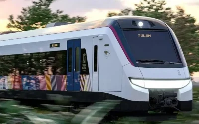
Mayan Train Map
Mayan Train Map You can click on extend screen on the “Mayan Train Map” to use the map in fullscreen and be able to filter the sites by map categories such as Mayan Train Route (under construction) highlighted in Yellow, ATMs, gas stations, energy stations for...
Yucatan Peninsula Map
Yucatan Peninsula Map You can click on extend screen on the “Yucatan Peninsula Map” to use the map in fullscreen and be able to filter the sites by map categories such as ATMs, gas stations, energy stations for electric vehicles, archaeological sites, Hospitals,...
Quintana Roo Mexico Map
Quintana Roo Mexico Map You can click on extend screen on the “Quintana Roo Mexico Map” to use the map in fullscreen and be able to filter the sites by map categories such as ATMs, gas stations, energy stations for electric vehicles, archaeological sites, Hospitals,...
Recomended activities Playa del Carmen

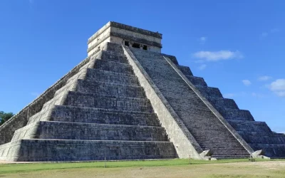
Tour to Chichen Itza
Private tour from Cancun or Riviera Maya to the Yucatan Peninsula. Ancient ruins and pyramids, colonial cities, cenote and Tequila Factory. Mexico Tours.
Trip Duration: 9-10 hours
Transportation: Included
Tourist Guide: Included

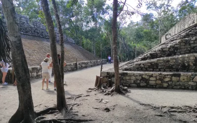
Tulum excursion
Private tour from Cancun or the Riviera Maya to the Archaeological zones of tulum, coba and cenote. Mexico Tours
Trip Duration: 9-10 hours
Transportation: Included
Tourist Guide: Included
Xcaret Park
Eco-Archaeological Park, dozens of activities for adults and children. m
Trip Duration: Full day (7 to 22 hours)
Transportation: Included
Tickets: Included
Lunch, buffet & drinks: Included

Xplor Park
Xplor is a park for fans of extreme sports and outdoor activities like Eco-High Zip lines, amphibious jeeps, cave rafting and much more. For adults and children over 5 years old.
Trip Duration: Full day
Transportation: Included
Tickets: Included
Lunch, buffet & drinks: Included

Xel ha Park
Xel-Ha is the world’s largest natural aquarium. A place where the combination of salt and fresh water combined with rocks create unique conditions for snorkeling.
Trip Duration: Full day
Transportation: Included
Tickets: Included
Lunch, buffet & drinks: Included
Stay Up to Date With The Latest News & Updates
Follow Us
Follow us to be updated about useful content in Riviera Maya
